


AeroGMS Measure - Area, Distance, Perimeter (GPS)
คำอธิบายของAeroGMS Measure - Area, Distance, Perimeter (GPS)
AeroGMS - Geographic Management System
AeroGMS is an extremely powerful Land Management Solution - a combination of custom built GIS and MIS, designed and developed by ElevenX Consultancy Pvt. Ltd.
‘AeroGMS MEASURE - Area, Distance, Perimeter’ is a robust utility from the AeroGMS ecosystem.
The WORLD’S HIGHEST RATED land measurement app. It’s the most accurate, easy to use and insanely useful, in its domain.
Noteworthy features:
Ad Free (Premium)
Measure Area, Perimeter, Distance by manually marking points on the map, using the ‘Add Point’ button.
Measure multiple polygons/polylines at once - just press the √ button.
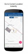
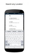
Global map search! Jump to any location and start measuring
Current location details
Precise and Accurate - values upto 2 decimal places
Latitude & Longitude information - there when you need it
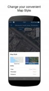
5 stunning map views - Default, Satellite, Dark Night, Silver Arrow & Aubergine Blue
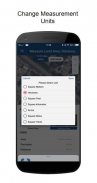
Area and Distance unit selection
Manual and accurate placement of pointers to make up for any mistake
Delete drawn polygons/polylines
Share the results with your friends
See Segmental measurements! - tap ‘More’ button after selecting the polygon/polyline
Ideal for:
Land Survey
Students
Roof Estimating - for installing solar panels
Urban Planners
Transport Planners
Civil Engineers
Architects
Municipal Corporation
PWD (Public Works Department)
Property Dealers
Real Estate/Construction Industry
Agriculture folks
Measure Area in:
Square Meters
Hectares
Square Feet
Square Kilometres
Acres
Square Miles
Square Yard
Measure Distance in:
Meters
Feet
Kilometer
Miles
Yards
Languages Supported:
English
Hindi
Marathi
Telugu
Let us know if support for more languages is required. Please email us at aerogmsdeveloper@gmail.com
Hence, AeroGMS Measure is the fastest, simplest and easiest app in its class, globally, for area measurement and distance measurement.
Question/Suggestions?
Tap the ‘Feedback’ option from the application menu and pour your heart out
SHARE WITH FRIENDS: Measure your favourite places and easily share screenshots with your friends
AeroGMS - ระบบการจัดการทางภูมิศาสตร์
AeroGMS เป็นโซลูชั่นการจัดการที่ดินที่ทรงพลังอย่างยิ่ง - การรวมกันของ GIS และ MIS ในตัวออกแบบและพัฒนาโดย ElevenX Consultancy Pvt จำกัด
'AeroGMS วัด - พื้นที่ระยะทางปริมณฑล' เป็นยูทิลิตี้ที่มีประสิทธิภาพจากระบบนิเวศ AeroGMS
แอปการวัดที่ดินที่ได้รับการจัดอันดับสูงสุดในโลก เป็นโดเมนที่แม่นยำใช้งานง่ายและมีประโยชน์อย่างมาก
คุณสมบัติที่สำคัญ:
โฆษณาฟรี (พรีเมียม)
วัดพื้นที่ปริมณฑลระยะทางด้วยการทำเครื่องหมายจุดบนแผนที่ด้วยตนเองโดยใช้ปุ่ม "เพิ่มจุด"
วัดหลายรูปหลายเหลี่ยม / polylines ในครั้งเดียว - เพียงแค่กดปุ่ม.
ค้นหาแผนที่ทั่วโลก! ข้ามไปยังตำแหน่งใดก็ได้แล้วเริ่มทำการวัด
รายละเอียดตำแหน่งปัจจุบัน
แม่นยำและแม่นยำ - ค่าได้มากถึง 2 ตำแหน่งทศนิยม
ข้อมูลละติจูดและลองจิจูด - เมื่อคุณต้องการ
5 มุมมองแผนที่ที่น่าทึ่ง - ค่าเริ่มต้นดาวเทียมกลางคืนมืด Silver Arrow & Aubergine Blue
การเลือกพื้นที่และระยะทาง
การชี้ตำแหน่งด้วยตนเองและแม่นยำเพื่อชดเชยความผิดพลาดใด ๆ
ลบรูปหลายเหลี่ยม / polylines ที่วาด
แบ่งปันผลลัพธ์กับเพื่อนของคุณ
ดูการวัดตามส่วน! - แตะปุ่ม ‘เพิ่มเติม’ หลังจากเลือกรูปหลายเหลี่ยม / รูปหลายเหลี่ยม
เหมาะสำหรับ:
สำรวจที่ดิน
นักเรียน
การประมาณหลังคา - สำหรับการติดตั้งแผงโซลาร์เซลล์
นักวางผังเมือง
นักวางแผนการขนส่ง
วิศวกรโยธา
สถาปนิก
บริษัท เทศบาล
PWD (กรมโยธาธิการ)
ตัวแทนจำหน่ายอสังหาริมทรัพย์
อสังหาริมทรัพย์ / อุตสาหกรรมก่อสร้าง
กลุ่มคนเกษตรกรรม
วัดพื้นที่ใน:
ตารางเมตร
เฮคเตอร์
ตารางฟุต
ตารางกิโลเมตร
เอเคอร์
สแควร์ไมล์
ลานกว้าง
วัดระยะทางใน:
เมตร
ฟุต
กิโลเมตร
ไมล์
หลา
ภาษาที่รองรับ:
อังกฤษ
ภาษาฮินดี
ฐี
กู
แจ้งให้เราทราบหากต้องการการสนับสนุนภาษาอื่น ๆ เพิ่มเติม โปรดส่งอีเมลถึงเราที่ aerogmsdeveloper@gmail.com
ดังนั้น AeroGMS Measure จึงเป็นแอพที่เร็วที่สุดง่ายที่สุดและง่ายที่สุดในระดับเดียวกันทั่วโลกสำหรับการวัดพื้นที่และการวัดระยะทาง
คำถาม / ข้อเสนอแนะ?
แตะตัวเลือก "คำติชม" จากเมนูแอปพลิเคชันและเทใจของคุณออก
แบ่งปันกับเพื่อน: วัดสถานที่โปรดของคุณและแชร์ภาพหน้าจอกับเพื่อนของคุณได้อย่างง่ายดาย
AeroGMS Measure - Area, Distance, Perimeter (GPS)--เวอร์ชั่น1.9.7
(19-09-2019)AeroGMS Measure - Area, Distance, Perimeter (GPS) - ข้อมูล APK
เวอร์ชั่น APK: 1.9.7แพ็คเกจ: org.elevenx.measureappเวอร์ชั่นล่าสุดของAeroGMS Measure - Area, Distance, Perimeter (GPS)


 4.5
4.5

แอปในประเภทเดียวกัน

คุณอาจจะชอบ...


